
Navionics NOT for Bahamas
- hayden
-
 Topic Author
- Offline
- Moderator
-

IF you are sailing the Bahamas, you need to be following the EXPLORE CHARTS and their clean waypoints. Some charting software includes this data, for example, our C-MAP NT charts from Jeppesen, includes the Explorer Data. I wrote to them and they confirmed this fact. I also have seen the Garmin Blue Chart App on the iPad and it too had the Explored Chart data, so it seemed. But you better write to Garmin and verify that.
Bottom line is, Navionics is not to be trusted in the Bahamas, but there are others that can be. You need to ask your app developer if the app includes the Explorer Chart Data and then get that in writing. Also, use the paper charts!
Hayden in Rock Sound Eleuthera, Bahamas
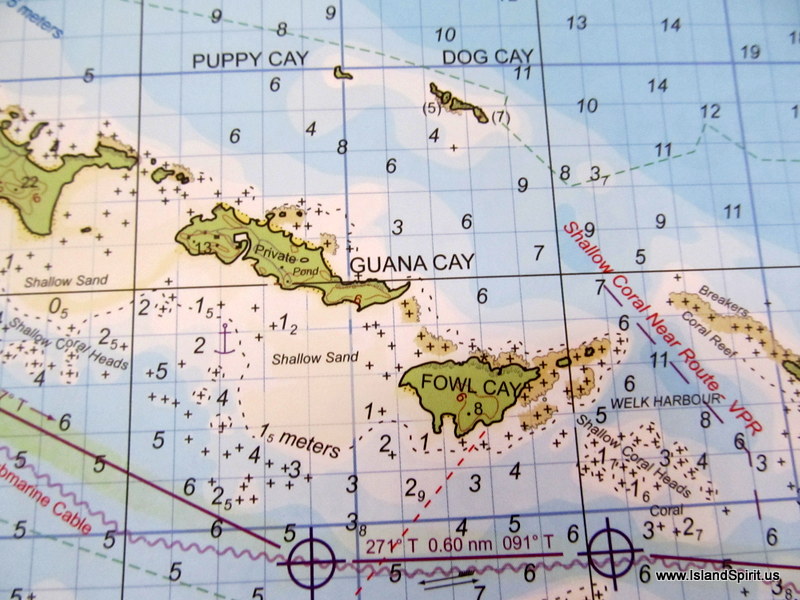
This is the PAPER EXPLORER CHARTS, look at the REEF next to FOWL Cey
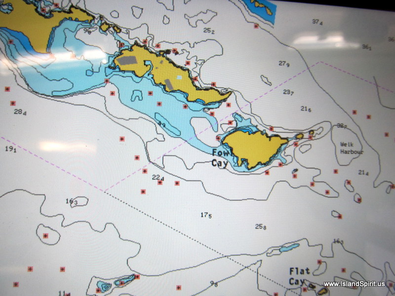
This is the NAVIONICS APP....LOOK....a course line next to FOWL CAY!
This is where the Cat sank due to this app !!!
Hayden Cochran
IP35-165 Island Spirit
IslandSpirit35.blogspot.com
Rock Hall, MD
Please Log in or Create an account to join the conversation.
- sblakely
-

- Offline
- New Member
-

- Posts: 12
- Thank you received: 0
Thanks, Hayden, this is essential information, very glad I read this BEFORE we got down there!
-- Bearboat
Please Log in or Create an account to join the conversation.
- hayden
-
Topic Author
- Offline
- Moderator
-
So, if you have a new IOS 6 iPad, go with Garmin Blue Charts, and of course, the Explorer Charts.
PS:
Navionics is PERFECT Maine to Key West to Tampa and even in the USVI from our experience.
Hayden
Hayden Cochran
IP35-165 Island Spirit
IslandSpirit35.blogspot.com
Rock Hall, MD
Please Log in or Create an account to join the conversation.
- rhpike
-

- Offline
- Junior Member
-

- Moondance - IP440 #35
- Posts: 36
- Thank you received: 5
Thanks for the update on chart quality in the Bahamas. Attached is a pic of Fowl Key using my version of the Navionics App. It shows numerous symbols for rocks in that same area and no route through there. One of the symbols mentions that explorer.com maps are superior. I wonder if perhaps you have an older version of Navionics? I don't know how to imbed the screenshot into this note, so will add it as a photo and provide the link.
Randy
S/V Moondance
IP440 #35
Houston, TX
This email address is being protected from spambots. You need JavaScript enabled to view it.
Please Log in or Create an account to join the conversation.
- rhpike
-
- Offline
- Junior Member
-
- Moondance - IP440 #35
- Posts: 36
- Thank you received: 5
Randy
S/V Moondance
IP440 #35
Houston, TX
This email address is being protected from spambots. You need JavaScript enabled to view it.
Please Log in or Create an account to join the conversation.
- rhpike
-
- Offline
- Junior Member
-
- Moondance - IP440 #35
- Posts: 36
- Thank you received: 5
ipyoa.com/photos/582-randy-pike/photo?albumid=348#photoid=4203
Randy
S/V Moondance
IP440 #35
Houston, TX
This email address is being protected from spambots. You need JavaScript enabled to view it.
Please Log in or Create an account to join the conversation.
- rhpike
-
- Offline
- Junior Member
-
- Moondance - IP440 #35
- Posts: 36
- Thank you received: 5
Any learnings about effectiveness of Navionics e-charts for charlottes in the Bahamas? I have Navionics Platinum chip for my Raymarine chart plotter.
Thanks,
Randy
Randy
S/V Moondance
IP440 #35
Houston, TX
This email address is being protected from spambots. You need JavaScript enabled to view it.
Please Log in or Create an account to join the conversation.
- rhpike
-
- Offline
- Junior Member
-
- Moondance - IP440 #35
- Posts: 36
- Thank you received: 5
Randy
S/V Moondance
IP440 #35
Houston, TX
This email address is being protected from spambots. You need JavaScript enabled to view it.
Please Log in or Create an account to join the conversation.
- hayden
-
Topic Author
- Offline
- Moderator
-
WARNING.....WARNING.....WARNING.....
What you have shown is the COMMUNITY LAYER in your app. Go to your settings and TURN THAT OFF.
Community Layer in Navionics is where you and I and any willy nilly sailor can add marks, buoys, waypoints and anything they want!!!! WHat?.....yup.....anyone can add a buoy anywhere and then you think this is GOOD TO FOLLOW.
That is a very dumb idea!!!!!
Here on your example, a user has added these marks AFTER THE CAT HIT THE REEF. Yes, this will prevent another boater from hitting this reef, BUT....this is NOT NAVIONICS data, it is data added by the users of the program.
So, If i were a bad person, I could now add buoys in bad places and people using the program would follow my points and run aground. This could be a fun and sick game.
If you use NAVIONICS:
#1: TURN OFF THE COMMUNITY LAYER, do not rely on the willy nilly sailor to add data
#2: DO NOT USE THIS IN THE BAHAMAS except for reference and study!
Thanks for adding the picture.
NOTE:
You can study the exact same issue in the FLORIDA ST. AUGUSTINE INLET. That inlet is MOVING all the time.....BUT.....users /community layer, in NAVIONICS have added buoys in the inlet. Yes they may be good today, but tomorrow when the USCG moves the channel buoys they are CRAP.
NEVER FOLLOW COMMUNITY LAYER DATA in NAVIONICS, it can be old and outdated.
Hayden
Hayden Cochran
IP35-165 Island Spirit
IslandSpirit35.blogspot.com
Rock Hall, MD
Please Log in or Create an account to join the conversation.
- Carey
-

- Offline
- New Member
-
- Posts: 7
- Thank you received: 0
If you zoom in a level or two from Hayden's screen shot the Navionics chart clearly shows that pass at Fowl Cay as "impassable". There is some user responsibility to do that in any questionable areas. I.e. the submerged breakwater at the Fernandina Beach inlet.
Please Log in or Create an account to join the conversation.
- rhpike
-
- Offline
- Junior Member
-
- Moondance - IP440 #35
- Posts: 36
- Thank you received: 5
Randy
S/V Moondance
IP440 #35
Houston, TX
This email address is being protected from spambots. You need JavaScript enabled to view it.
Please Log in or Create an account to join the conversation.
- rhpike
-
- Offline
- Junior Member
-
- Moondance - IP440 #35
- Posts: 36
- Thank you received: 5
Randy
S/V Moondance
IP440 #35
Houston, TX
This email address is being protected from spambots. You need JavaScript enabled to view it.
Please Log in or Create an account to join the conversation.
- hayden
-
Topic Author
- Offline
- Moderator
-
Thank for that photo, that is closer to the Explorer charts.
Fresh Boarder means new user with a few posts
Karma, goes up as users like your postings.
These are just fun sections of this app.
Hayden
Hayden Cochran
IP35-165 Island Spirit
IslandSpirit35.blogspot.com
Rock Hall, MD
Please Log in or Create an account to join the conversation.
- Carey
-
- Offline
- New Member
-
- Posts: 7
- Thank you received: 0
Definitely not passable !!!
Please Log in or Create an account to join the conversation.
- hayden
-
Topic Author
- Offline
- Moderator
-
That screen capture is showing the COMMUNITY LAYER with marks that were put into Navionics AFTER the cat hit the reef. Turn off the community layer and THEN look at this area east of FOWL CAY.
I am not trusting any COMMUNITY LAYER pins, buoys or marks. I want the chart markings and that is all.
The fact that Navionics is allowing users to add buoys and marks into their software is really messed up. It is not like Active Captain where the user data is supporting data to help. These community layer looks like OFFICIAL BUOY MARKS, and people are now trusting them. If you look at Navionics for ST. AUGUSTINE, you will see the same issue of community layer buoys added my users.
Hayden
Hayden Cochran
IP35-165 Island Spirit
IslandSpirit35.blogspot.com
Rock Hall, MD
Please Log in or Create an account to join the conversation.
- shawnee
-

- Offline
- Moderator
-
- Posts: 59
- Thank you received: 7
Drew S.
Please Log in or Create an account to join the conversation.
- rhpike
-
- Offline
- Junior Member
-
- Moondance - IP440 #35
- Posts: 36
- Thank you received: 5
Randy
S/V Moondance
IP440 #35
Houston, TX
This email address is being protected from spambots. You need JavaScript enabled to view it.
Please Log in or Create an account to join the conversation.
- shawnee
-
- Offline
- Moderator
-
- Posts: 59
- Thank you received: 7
I've been using an old version of Max Sea (v11.0 I think) running on a Panasonic toughbook with WinXP. I got it back in 2004, so it's rather an antique. But the newer versions don't seem to be much better for charting and downloading waypoints to the GPS. I have't seen a good reason to upgrade hardware and software, other than using iPad as good backup. I may get a 5" garmin with charting as upgrade to old GPS, and get that mirrored on the iPad. But MaxSea is quite nice (other than WinXP) and it seamlessly integrates the raster charts. If more detailed paper charts are in it's library, it will switch to those as you zoom in. But if you zoom in more that the data is available, it is immediately obvious.
I think there are other good raster chart plotting programs now. I just haven't looked into them.
Drew S
Please Log in or Create an account to join the conversation.
- Marko Markovich
-

- Offline
- New Member
-
- Posts: 17
- Thank you received: 1
Please Log in or Create an account to join the conversation.
- hayden
-
Topic Author
- Offline
- Moderator
-
The Bahamas chart data that everyone lives by is THE EXPLORER CHARTS. This data is owned by C-Map / Jeppesen. Another company, Navionics uses their own chart data for the Bahamas. Navionics DOES NOT USE or Pay For the Explorer Chart Data. So, it is key when sailing the Bahamas that we use Explorer Chart Data. Use C-Map for Bahamas. That is what I understand is the best. Note: We have now used C-Map 5 years in the Bahamas and we run a Samsung Tab 2 tablet next to this with Navionics and we have seen MANY errors on the Navionics charts in the Bahamas. I do find Navionics perfect on the entire USA East Coast. IT also is not bad in the Abaco, but south in the Exumas, not good.
Hayden
Hayden Cochran
IP35-165 Island Spirit
IslandSpirit35.blogspot.com
Rock Hall, MD
Please Log in or Create an account to join the conversation.
We have 1831 guests and no members online
Disclaimer
Island Packet and Island Packet Yachts are registered trademarks of IPY (Island Packet Yachts, Inc.). IPYOA and The Island Packet Yacht Owners Association, have no affiliation with IPY, the Island Packet Yacht Company. Throughout our IPYOA Facebook Group and on this IPYOA.com website the terms Island Packet and Island Packet Yachts are used for identification purposes only. This use is FAIR USE and NOMINATIVE. We are NOT a yacht manufacturer we are a yacht owners group.
Sincerely,
The International IPYOA administration team.